
Copyright of Photo: Namibia Roads Authority
NAMIBIA PHOTO LIBRARY: DAMARALAND: ERONGO AND KUNENE REGIONS
SERIOUS WARNING TO FOREIGN TOURISTS
A serious word of warning should be levelled travelling "off-road" in the northern parts of the former Damaraland (Kunene Region). Inexperienced foreign tourists should never leave the proclaimed road network. If they travel "off-road" then they should never travel with one vehicle only and they should ask advice from knowledgeable Namibians. They should use appropriate vehicles and equipment with sufficient fuel and water. Tracks outside Namibia's excellent road system are remote and desolate and are in many cases never properly built and are not maintained. Even if travelling on Namibia's well maintained gravel and earth roads, a speed of 90 km/h should never be exceeded.
FROM OKAHANDJA VIA SWAKOPMUND/WALVIS BAY TO THE SPITZKOPPE
Copyright of Photo: Namibia Roads Authority

Termites' Nest: between Okahandja and Wilhelmstal: with Matthias
Hipp, my Grandson: August 2002: Erongo Region
Copyright of Photo: Dr. Klaus Dierks

Namibia's Luxury Train, the "Desert Express" at the
Station Stingbank in the Namib Desert near Ebony: 30 km west of !Usakos: 04.09.2004:
Ultimate Railway Experience through Africa's Gem, Namiba
Copyright of Photo: Dr. Klaus Dierks


View to the South into the Khan River Valley at the Station
Stingbank in the Namib Desert near Ebony: 30 km west of !Usakos: 04.09.2004 at Sunset: The
Night is approaching from the East
Copyright of Photos: Dr. Klaus Dierks

View to the South into the Khan River Valley at the Station
Stingbank in the Namib Desert near Ebony: 30 km west of !Usakos: 04.09.2004 at Sunset: My
Wife, Karen Dierks, née Von Bremen to the Right, and my youngest Daughter: Annette
Dierks
Copyright of Photo: Dr. Klaus Dierks

View to the South into the Khan River Valley at the Station
Stingbank in the Namib Desert near Ebony: 30 km west of !Usakos: 04.09.2004 at Sunset:
German Fortifications from World War One near Pforte-Jakkalswater-Riet against the from
Swakopmund invading South African Troups in March 1915
Copyright of Photo: Dr. Klaus Dierks

Swakopmund's Stone Jetty (Mole) with the Light House in the
Background
Copyright of Photo: Dr. Klaus Dierks

The "Hohenzollern Haus" at Swakopmund
Copyright of Photo: Dr. Klaus Dierks


The Sand Dunes south of the Swakop River at Swakopmund
Copyright of Photos: Dr. Klaus Dierks


Official Handing-Over of the four Prototypes of Diesel-Electric
Locomotives (1 850 kW) by the China South Locomotives and Rolling Stock Industry which in
Future will be assembled in Namibia (Usakos) to the Chairman of TransNamib Holding: Dr.
Klaus Dierks: Walvis Bay: 04.09.2004
Copyright of Photos: Dr. Klaus Dierks

Namibia's Luxury Train, the "Desert Express" at Walvis
Bay: 04.09.2004: Ultimate Railway Experience through Africa's Gem, Namiba
Copyright of Photo: Dr. Klaus Dierks


Memorial for Gottlieb "Maxuili" Nathaniel near the
Accident Spot at the Junction of Main Road 36 with District Road 1983 east of Walvis Bay
Copyright of Photos: Dr. Klaus Dierks


Port Railway Line: Walvis Bay: Second Railway Line in Namibia:
1897
Copyright of Photos: Dr. Klaus Dierks


Seal Colony at Cape Cross
Copyright of Photos: Dr. Klaus Dierks

District Road 1925 with the "Große Spitzkoppe 1 728m"
in the Background: From the Southwest: Erongo Region
Copyright of Photo: Dr. Klaus Dierks


District Road 3716 with the "Große Spitzkoppe" in the
Background: From the South
Copyright of Photos: Dr. Klaus Dierks


Gemstone People near the "Große Spitzkoppe" in the
Erongo Region
Copyright of Photos: Dr. Klaus Dierks

The "Große Spitzkoppe" from the North
Copyright of Photo: Dr. Klaus Dierks

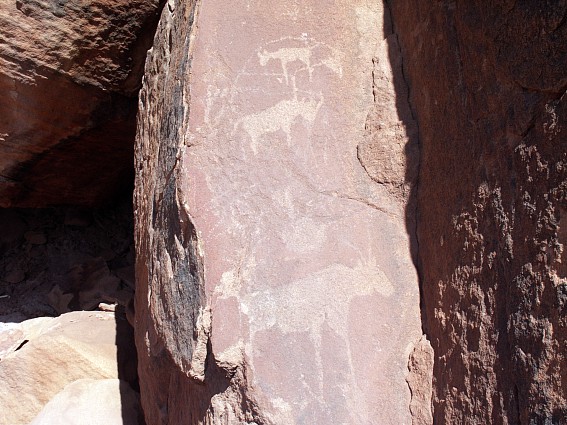
Rockpainting in the "Große Spitzkoppe" Massif
(ca. 4400 - 100 B.C.)
Copyright of Photo: Dr. Klaus Dierks


The "Bushmen Paradise" in the Spitzkoppe Massif:
Erongo Region
Copyright of Photos: Dr. Klaus Dierks
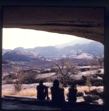

Cave in the "Bushmen Paradise" in the Spitzkoppe
Massif
Copyright of Photos: Dr. Klaus Dierks


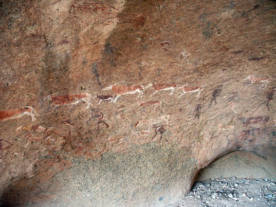
Rockpainting in the Cave in the "Bushmen Paradise" (ca. 4400 - 100 B.C.)
Copyright of Photos: Dr. Klaus Dierks

Scene in the Spitzkoppe Massif: Erongo Region
Copyright of Photo: Dr. Klaus Dierks
![]()
FROM THE ERONGO MOUNTAINS VIA OMARURU AND OKOMBAHE TO THE BRANDBERG
Copyright of Photo: Namibia Roads Authority


Farm Road in the Erongo Mountains between Ekuta and Kuduberg:
Erongo Region
Copyright of Photos: Dr. Klaus Dierks


Scenes in the Erongo Mountains: Farm Kuduberg: Erongo Region
Copyright of Photos: Dr. Klaus Dierks

Rock Engravings in the Erongo Mountains: Farm Kuduberg: Erongo
Region
Copyright of Photo: Dr. Klaus Dierks


Bushveld Elephant Shrews: Erongo Mountains: Farm Kuduberg:
Erongo Region
Copyright of Photos: Dr. Klaus Dierks


Karoowagter (Rotauge): Erongo Mountains: Farm Kuduberg: Erongo
Region
Copyright of Photos: Dr. Klaus Dierks


The "Franke Tower" in Omaruru, remembering the Battle
of Omaruru between Germans and Ovaherero, 17.01. - 04.02.1904, Erongo Region
Copyright of Photos: Dr. Klaus Dierks


Historical Graves on the Rhenish Missionary Cemetery in Omaruru,
Erongo Region
Copyright of Photos: Dr. Klaus Dierks

Landscape near Okombahe: View to the Basalt Mountain formed by
Volcanic Activities during the Break-Up of the Gondwana Continent, 130 Million Years ago:
Karoo Sequence: View to the South with Erongo in the Background, Erongo Region
Copyright of Photo: Dr. Klaus Dierks

Rhenish Missionary Church of Okombahe: Founded on 17.11.1870:
Erongo Region
Copyright of Photo: Dr. Klaus Dierks


Rhenish Missionary Cemetery of Okombahe: Erongo Region
Copyright of Photos: Dr. Klaus Dierks

Damara Restaurant at Okombahe: Erongo Region
Copyright of Photo: Dr. Klaus Dierks

The Brandberg with the Königsstein is Namibia's highest
Mountain:
2 646 m: View from the East into the Tsisab Valley: The Mountain is composed of a single
mass of granite created 120 Million Years ago, a Time of tremendous geological Upheaval in
the Earth's History, when the old Gondwana Continent broke apart, separating Africa from
South-America: Erongo Region: April 1971
Copyright of Photo: Dr. Klaus Dierks

The Brandberg from the East into the Tsisab Gorge: with District
Road 2359: Erongo Region, March 2003
Copyright of Photo: Dr. Klaus Dierks

The Brandberg from the East into the Tsisab Gorge: View to the
West: With Königsstein in the Background: Erongo Region, March 2003
Copyright of Photo: Dr. Klaus Dierks

Dassie Rat in the Tsisab Gorge: Erongo Region, March 2003
Copyright of Photo: Dr. Klaus Dierks

The Tsisab Gorge in the Brandberg: Erongo Region: View to South
West: There are so far approximately 1 000 painted Shelters with 45 000 individual
Paintings in the Brandberg Massif identified
Copyright of Photo: Dr. Klaus Dierks


Prehistoric Stone Circle Architecture of Nomadic Pastoralists in
the Tsisab Gorge in the Brandberg (Around 1500 A.D.): View to the North-East: Erongo
Region, March 2003
Copyright of Photos: Dr. Klaus Dierks

Rockpaintings in the Tsisab Gorge in the
Brandberg (ca. 4400 - 100 B.C.): The famous "White Lady" Rockpainting in Maack's
Shelter: Recent Research shows that the Figures are of pure Namibian Origin, April 1971
Copyright of Photo: Dr. Klaus Dierks


The Rock Paintings in Maack's Shelter with
"White Lady" in March 2003: A Number of the Figures, including the "White
Lady", display Both white and red Body Paint and are highly decorated: There is a
lavish Use of Bead Strings and Bands to decorate the Knees, Ankles, Arms, Neck and Hair of
the Figures: Since the older Layers of Paintings and the simpler monochrome Figures could
perhaps be called "Bushman-Style", it is possible that the San (Bushmen) were in
the area in the distant Past: The more complex Figures appear to have been painted later,
since they mostly overlie the "Bushman Style" Paintings: We can assume that the
Age of these Paintings is at least 2000 Years old and many are much older
Copyright of Photos: Dr. Klaus Dierks

Ascent from Maack's Shelter to the Giraffe Cave
in the Brandberg, Tsisab Gorge: View to the Southwest, March 2003
Copyright of Photo: Dr. Klaus Dierks

Rockpaintings in the Tsisab Gorge in the
Brandberg (ca. 4400 - 100 B.C.): The Giraffe Cave: The Paintings are, usually realistic
Portrayals, although they are often drawn with a twisted Perspective: The human Figures
have the Trunk, Legs and Head painted in Profile while the Shoulders and Arms are depicted
from a Frontal Perspective, March 2003
Copyright of Photo: Dr. Klaus Dierks

Ascent from the Giraffe Cave to the Ostrich Cave
in the Brandberg, Tsisab Gorge: View to the North East, March 2003
Copyright of Photo: Dr. Klaus Dierks

Rockpaintings in the Tsisab Gorge in the
Brandberg (ca. 4400 - 100 B.C.): The Ostrich Cave in March 2003: Many of the Paintings
display Brush Marks, therefore we can assume that the Tools used were probably Animal Hair
Brushes: The Colours used were Earth Colours, Red Hematite, Yellow Ochre, Charcoal, Black
Manganese and Calcium Carbonate
Copyright of Photo: Dr. Klaus Dierks

Ascent from the Ostrich Cave in the Brandberg to
Jochmann's Shelter, Tsisab Gorge: View to the South, March 2003
Copyright of Photo: Dr. Klaus Dierks

View from Jochmann's Shelter, Tsisab Gorge: View
to the North East, March 2003
Copyright of Photo: Dr. Klaus Dierks

Rockpaintings in the Tsisab Gorge in the
Brandberg (ca. 4400 - 100 B.C.): Jochmann's Shelter (Lion), March 2003
Copyright of Photo: Dr. Klaus Dierks

Rockpaintings in the Tsisab Gorge in the
Brandberg (ca. 4400 - 100 B.C.): Jochmann's Shelter (Snake and Giraffe), March 2003
Copyright of Photo: Dr. Klaus Dierks

Graffiti by the German Surveyor, Lieutenant
Jochmann: from the Year1909 in Jochmann's Shelter: Erongo Region
Copyright of Photo: Dr. Klaus Dierks


Welwitschia Mirabilis (Welwitschiaceae):
Unique Namibian Desert Plant: (100 years old and more): Between the Hungorob Gorge in the
Brandberg and the Messum Crater: Erongo Region: March 2003
Copyright of Photos: Dr. Klaus Dierks

Good Look Cairn" (Nama: Heitsi-Eibib or Haitse-aibeb)
established by Pastoral Nomads in the Brandberg: View from the West into the Hungorob
Gorge: March 2003: Erongo Region
Copyright of Photo: Dr. Klaus Dierks
![]()
FROM THE BRANDBERG VIA THE UGAB TO GAI-AS AND TWYFELFONTEIN

Copyright of Photo: Namibia Roads Authority


View from the East into the Ugab Valley (Boundary between Erongo
and Kunene Regions): View to the West: March 2003
Copyright of Photos: Dr. Klaus Dierks

View from the East into the Ugab Valley and a Valley leading to
the Doros Crater and the Mikberg Mountains: March 2003
Copyright of Photo: Dr. Klaus Dierks


Prehistoric Stone Circle Architecture of Nomadic Pastoralists in
the Ugab Valley (Ugab Crossing)(Around 1600 A.D.): Site 1: March 2003
Copyright of Photos: Dr. Klaus Dierks

Prehistoric Pathway used by Nomadic Pastoralists in the Ugab
Valley (Ugab Crossing)(Around 1600 A.D.): Access to Site 1: March 2003
Copyright of Photo: Dr. Klaus Dierks

Prehistoric Stone Circle Architecture of Nomadic Pastoralists in
the Ugab Valley (Ugab Crossing)(Around 1600 A.D.): Site 2: March 2003
Copyright of Photo: Dr. Klaus Dierks


Prehistoric Stone Circle Architecture of Nomadic Pastoralists in
the Ugab Valley (Ugab Crossing)(Around 1600 A.D.): Site 5: March 2003
Copyright of Photos: Dr. Klaus Dierks

Prehistoric Stone Circle Architecture of Nomadic Pastoralists in
the Ugab Valley (Ugab Crossing)(Around 1600 A.D.): Site 11: March 2003
Copyright of Photo: Dr. Klaus Dierks


Landscape between Ugab River and Mikberg Mountain: There are
only nearly invisible Tracks to travel: View to the North in Direction Mikberg: March
2003: Kunene Region
Copyright of Photos: Dr. Klaus Dierks

Landscape between Ugab River and Mikberg Mountain: View to the
South in Direction Ugab River and the Goboboseb Mountains: March 2003: Kunene Region
Copyright of Photo: Dr. Klaus Dierks


Landscape between Mikberg Mountain and Huab River: View to the
East in Direction Doros Crater and Twyfelfontein: March 2003: Kunene Region
Copyright of Photos: Dr. Klaus Dierks


Prehistoric Site of Gai-As: Between Doros Crater and Huab River:
For Millenniums the Hunter Gatherers and later the Nomadic Pastoralists used the
Waterhole of Gai-As: Now the Hole is visited by Desert Elephants and Desert Rhinoceros:
March 2003: Kunene Region
Copyright of Photos: Dr. Klaus Dierks


Prehistoric Site of Gai-As: Site 1: Rock Engravings by
Hunter-Gatherers: C1 to E Periods: 4400 B.C. - 1200 A.D.:
Approximately 2000 Years Old: March 2003: Kunene Region
Copyright of Photos: Dr. Klaus Dierks


Prehistoric Site of Gai-As: Site 2: Rock Engravings by
Hunter-Gatherers: C1 to E Periods: 4400 B.C. - 1200 A.D.:
Approximately 2000 Years Old: March 2003: Kunene Region
Copyright of Photos: Dr. Klaus Dierks


Prehistoric Site of Gai-As: Site 3: Stone Circle Architecture of
Nomadic Pastoralists: "High Buildings": Approximately between 1500 and 1900
A.D.: March 2003: Kunene Region
Copyright of Photos: Dr. Klaus Dierks


Prehistoric Site of Gai-As: Site 9: Stone Circle Architecture of
Nomadic Pastoralists: North West Settlement: Approximately between 1500 and 1900 A.D.:
March 2003: Kunene Region
Copyright of Photos: Dr. Klaus Dierks


Prehistoric Site of Gai-As: Site 6: Stone Circle Architecture of
Nomadic Pastoralists: South West Settlement: Approximately between 1500 and 1900 A.D.:
March 2003: Kunene Region
Copyright of Photos: Dr. Klaus Dierks


Prehistoric Site of Gai-As: Site 11: Stone Circle Architecture
of Nomadic Pastoralists: East Settlement: Approximately between 1500 and 1900 A.D.: March
2003: Kunene Region
Copyright of Photos: Dr. Klaus Dierks


Petrified Forest: 11 km Northeast of Gai-As: The Petrified
Trunks originate from the Dwyka and Etjo Periods: 280 to 260 Million Years Ago: Kunene
Region: March 2003
Copyright of Photos: Dr. Klaus Dierks


Landscape between Mikberg Mountain, Doros Crater and the Organ
Pipes at the Burnt Mountain near Twyfelfontein: March 2003: Kunene Region
Copyright of Photos: Dr. Klaus Dierks

Twyfelfontein in the Kunene Region: with Africa's largest known
Collection of Rock Engravings, April 1980
Copyright of Photo: Dr. Klaus Dierks


Images of the Rocky Crater of Twyfelfontein: March
2003: In 1921 Reinhardt Maack makes known his Discovery of the Petroglyphs
and Rock Paintings on the Sandstone of the Etjo Formation at Twyfelfontein (Ui-Ais)(C1 to
E periods: 4400 BC - 1400 AD). The Petroglyphs are recorded by Ernst Rudolph Scherz from
1950 onwards. He reports that there are 2 500 Rock Engravings on more than 200 Sandstone
Slabs: He also discovers some Rockpaintings housed in Sandstone Rock Shelters
Copyright of Photos: Dr. Klaus Dierks

Twyfelfontein with pre-historic Stone Circle of Nomadic
Pastoralists (Possible Transition from Windshields to Hut Foundations: D Period between
A.D. and 1200 A.D.): Kunene Region: March 2003
Copyright of Photos: Dr. Klaus Dierks


Twyfelfontein: Rock Engravings: C1 to E Periods:
4400 B.C. - 1200 A.D.: April 1980: Kunene Region
Copyright of Photos: Dr. Klaus Dierks


Twyfelfontein: Rock Engravings: Later Stone Age
Hunter-Gatherer Culture: C1 to E Periods: 4400 B.C. - 1200 A.D.: Some of the
Engravings may be as old as 7000 Years and even much older: The Abstract Designs were
probably done by earlier Artists: March 2003: Kunene Region
Copyright of Photos: Dr. Klaus Dierks


Twyfelfontein with Rockpaintings: C1 to E Periods: 4400 B.C. - 1200 A.D.: The Rockpaintings
are younger than the Rockengravings: Kunene Region: March 2003
Copyright of Photos: Dr. Klaus Dierks
![]()
FROM KAMANJAB VIA THE GROOTBERG TO PALMWAG AND SESFONTEIN

Copyright of Photos: Namibia Roads Authority

Welwitschia Mirabilis (Welwitschiaceae):
Unique Namibian Desert Plant: (100 years old and more): Near Petrified Forest: Kunene
Region: April 1975
Copyright of Photo: Dr. Klaus Dierks

Petrified Forest (with Alexander Dierks and Katrin
Dierks-Lecomte): 1977: Kunene Region
Copyright of Photo: Dr. Klaus Dierks

"Vingerklip" (Finger Rock) near the Ugab River west of
Outjo in the Kunene Region, 1980
Copyright of Photo: Dr. Klaus Dierks

District Road 2620: Khorixas - Palmwag with Grootberg Mountains
in the Background: Kunene Region, 1978
Copyright of Photo: Dr. Klaus Dierks

Farm Austerlitz with Grootberg Mountains in the Background:
Kunene Region, 1978
Copyright of Photo: Dr. Klaus Dierks

Veld during the Rainy Season in the Kamanjab Area in the Kunene
Region, 1987
Copyright of Photo: Dr. Klaus Dierks


Images from the Grootberg Area on the Farm Otjihavera in
the Kunene Region, along Main Road 126 from Kamanjab to Bergsig, with Mountain Zebras
(Hartmann Zebras) on the right Photo, September 2004
Copyright of Photo: Dr. Klaus Dierks

Sunset on the Wildlife Resort Palmwag in the Kunene Region, 1981
Copyright of Photo: Dr. Klaus Dierks

District Road 3607 (now Main Road 128): Palmwag to Sesfontein in
the Kunene Region, 1978
Copyright of Photo: Dr. Klaus Dierks

River Plain of the Hoanib River near Sesfontein in the Kunene
Region, 1978
Copyright of Photo: Dr. Klaus Dierks

Veld during the Rainy Season south of Sesfontein, 1978
Copyright of Photo: Dr. Klaus Dierks


Veld during the Dry Season south of Sesfontein, September 2004
Copyright of Photos: Dr. Klaus Dierks

Sesfontein, 1978
Copyright of Photo: Dr. Klaus Dierks


The German Fort (built by Karl Schmidt 1904-1906 and rebuilt as
Lodge in the 1990s) and the German Cemetery at Zesfontein (Afrikaans: Sesfontein),
September 2004
Copyright of Photos: Dr. Klaus Dierks


The German War Cemetery at Outjo (Kunene Region) remembers the
Skirmish of Naulila in Angola during World War One, October and December 1914 and various
Skirmishes and Battles during the Uprisings of Namibians against the German Colonial Power
between 1897 and 1904, Photos taken in September 2004
Copyright of Photos: Dr. Klaus Dierks