
Copyright of Photo: Namibia Roads Authority

NAMIBIA PHOTO LIBRARY: CAPRIVI REGION
KATIMA MULILO AND THE ZAMBEZI BRIDGE
Copyright of Photo: Namibia Roads Authority
Aerial View on Okavango Delta in Direction Shakawe and Namibia:
View to the East: February 2003
Copyright of Photo: Dr. Klaus Dierks

Aerial View on Kwando/Linyanti/Chobe River System: Near
Lianshulu: View to the East: February 2003
Copyright of Photo: Dr. Klaus Dierks

Katima Mulilo is the regional Capital of the Caprivi Region:
View over the Zambezi River to Sesheke in Zambia: June 1981
Copyright of Photo: Dr. Klaus Dierks

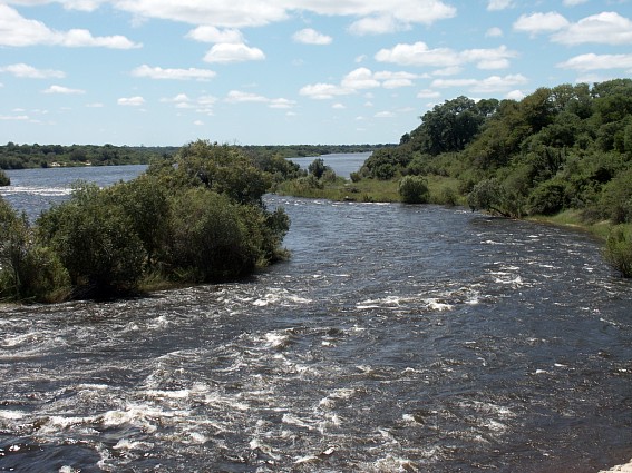
Sunset at the Zambezi River at Katima Mulilo: Dry Season: June
1981
Copyright of Photo: Dr. Klaus Dierks


Sunset at the Zambezi River at Katima Mulilo: February 2003
Copyright of Photos: Dr. Klaus Dierks


View from Katima Mulilo (Caprivi Cabins): View over the Zambezi
River to Sesheke in Zambia: Caprivi Region: During the Rainy Season: February 2003
Copyright of Photos: Dr. Klaus Dierks


Zambezi River Bridge (Bridge 508) between Katima Mulilo and
Sesheke in Zambia is built on the Katima Rapids near the Namibia/Zambia Border
Beacon (17�28'29,29" south, 24�17'50,04" east) with "S.W.A." (South
West Africa) on West Side and "N.A." (Northern Rhodesia) on East Side
Copyright of Photos: Dr. Klaus Dierks

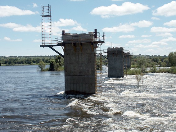

Construction of the Zambezi River Bridge (Bridge 508) between
Katima Mulilo and Sesheke in Zambia: Built on Katima Rapids (The Bridge is situated in
Zambia, the West-Abutment is 10 m from Boundary Beacon between Namibia and Zambia):
Radius: 1 600 m: Total Length: 877, 40 m : 17 Spans @ 47,10 m each with two End
Spans @ 38,35 m: Total Width of Bridge: 10,10 m; Incremental Launching of the Deck over
the entire Bridge from West to East has still to take place: 18 Piers and the
West-Abutment have been completed: Progress on February, 12th 2003: View from West to East:
Construction Time: 24 Months as from April 2002: Costs: approx. 9 US $ Million:
The Bridge is the last missing Link in the Walvis Bay Corridor from Walvis Bay to
Lubumbashi in the Democratic Republic of the Congo
Copyright of Photos: Dr. Klaus Dierks

Construction of the Zambezi River Bridge (Bridge 508) between
Katima Mulilo and Sesheke in Zambia: The Eastern Abutment is excavated and the Foundation
Base is prepared: Progress on February, 12th 2003
Copyright of Photo: Dr. Klaus Dierks


Construction of the Zambezi River Bridge (Bridge 508) between
Katima Mulilo and Sesheke in Zambia: The Piers were constructed with the Aid of a
Causeway from both Sides of the River with an Opening in the Middle of the River of 100 m
Width during the dry Season: The Causeway, which is in the Process to be removed, consists
of a Rockfilldam and Precast Culvert Sections: The Abutments and 18 Piers were built from
the Causeway with the Assistance of Cofferdams, all on Spread Footings, mostly on Hard
Rock (Basalt) within the River (30 MPa Compression Strength; Max. Height: 19,90 m above
foundation, 14,40 m above Low Water, 2,60 m above Highwater (High Flood with 100 Years
Probability)): Progress on February, 12th 2003: View from East to West
Copyright of Photos: Dr. Klaus Dierks

Construction of the Zambezi River Bridge (Bridge 508) between
Katima Mulilo and Sesheke in Zambia: Incremental Launching of the Deck over the entire
Bridge from West to East from West Abutment to East Abutment: First Stage is to put the
Reinforcement in to the Segment (Hollow Prestressed Beam 31,4 m long and 10,10 m wide) in
the "Reinforcing Bay"; Stage 2 (Day 1) sees the Erection of the Shuttering for
Ground slab and the two Webs of the Box Girder, after the assembled Reinforcing has been
shifted into the "Casting Bay"; At Stage 3 (Day 2) the casting of the Ground
Slab and the two Webs takes place; At Stage 4 (Day 3) the Shuttering is partly removed and
the Shuttering for the Top Slab is erected; Stage 5 (Day 4) sees the Concreting of the Top
Slab; Stage 6 (Day 5) is a Rest Day in order to provide for the Hardening of the Concrete;
At Stage 7 (Day 6) the Prestressing for the Construction Stage of the Box Girder (3 Days
Compression Strength of the Concrete: 32 MPa) takes place and at Stage 8 (Day 7, momentary
on Monday) the Launching of the 31,4 m Segment to the next Position takes place.
Copyright of Photo: Dr. Klaus Dierks

Construction of Zambezi River Bridge (Bridge 508) between Katima
Mulilo and Sesheke in Zambia: Incremental Launching of the Deck: After the finished
Reinforcement has been moved from the Reinforcing Bay into the Casting Bay, the Segment
(31,4 m long) is casted and prestressed and ready to be pushed into the "Casting
Bay": Progress on February, 12th 2003: Seventh Stage: After Reaching of the necessary
Concrete Compression Strength (32 MPa; Ultimate Compression Strength: 45 MPa) and the
Prestressing, the first Segment is pushed forward by the Length of one Segment over the
Bridge Substructure (Abutment and Piers): When the First Segment has reached the other End
of the Bridge (East Abutment): 28 Segments @ 31,40 m each will have been pushed
Copyright of Photo: Dr. Klaus Dierks


Construction of Zambezi River Bridge (Bridge 508) between Katima
Mulilo and Sesheke in Zambia: Incremental Launching of the Deck: Seventh Stage: The
Segment (31,4 m long) which is casted and prestressed and ready to be pushed, needs for
the Launching Process a "Launching Nose (Mass 60 Tons)" in order to minimise
Positive and Negative Bending Moments during the Launching Process: Progress on February,
12th 2003:
Copyright of Photos: Dr. Klaus Dierks

Construction of Zambezi River Bridge (Bridge 508) between Katima
Mulilo and Sesheke in Zambia: Incremental Launching of the Deck: Seventh Stage: The
Segment No. 7 (31,4 m long) which was casted and prestressed and is today pushed over Pier
No. 7 with an average Launching Speed of 10 m/hour: View on top of Pier 7 to the
West (Katima Mulilo Side): Progress on May, 19th 2003:
Copyright of Photos: Dr. Klaus Dierks


Construction of Zambezi River Bridge (Bridge 508) between Katima
Mulilo and Sesheke in Zambia: Incremental Launching of the Deck: Seventh Stage: The
Segment No. 7 (31,4 m long) which was casted and prestressed and is today pushed over Pier
No. 7 with an average Launching Speed of 10 m/hour: View on top of Pier 7 to the
East (Sesheke Side) : Progress on May, 19th 2003:
Copyright of Photos: Dr. Klaus Dierks

The Reinforcing Steel in the Reinforcing Bay will be pushed into
the into the Casting Bay which is to be seen in the Foreground: Progress: May 2003
Copyright of Photo: Dr. Klaus Dierks

Construction of Zambezi River Bridge (Bridge 508) between Katima
Mulilo and Sesheke in Zambia: Incremental Launching of the Deck: Seventh Stage: The
Segment No. 7 (31,4 m long) which was casted and prestressed and is today pushed over Pier
No. 7 with an average Launching Speed of 10 m/hour: View from the western Abutment:
The total Deck Mass is currently 5 000 t: With a Friction Value of 0,02% the Launching
Force is 100 t (initially: 300t): At the End, with the total Length of the Box Girder
pushed over the River into the final Position, the total Deck Mass will be 13
000 t with a Launching Force of 260 t (750 t): Progress on May, 19th 2003:
Copyright of Photo: Dr. Klaus Dierks


During the Launching Process the Prestressing Strings have to be
grouted from Time to Time: Progress: May 2003
Copyright of Photos: Dr. Klaus Dierks


Construction of Zambezi River Bridge (Bridge 508) between Katima
Mulilo and Sesheke in Zambia: View to the East: Progress on May, 19th 2003:
Copyright of Photos: Dr. Klaus Dierks


Construction of Zambezi River Bridge (Bridge 508) between Katima
Mulilo and Sesheke in Zambia: View to the West: Progress on May, 19th 2003:
Copyright of Photos: Dr. Klaus Dierks

Construction of Zambezi River Bridge (Bridge 508) between Katima
Mulilo and Sesheke in Zambia: View to the East from the Katima Mulilo Side: The Box Girder
Deck will reach the Sesheke Bank in August/September 2003: After this Date the final
Bridge Bearings have to be mounted and the entire Bridge has to be prestressed for the
Design Traffic Loads: The Bridge will be completed on Schedule and opened to Traffic
during April 2004
Copyright of Photo: Dr. Klaus Dierks
FROM KATIMA MULILO TO NGOMA AT THE CHOBE RIVER AND THE LIAMBEZI LAKE
Copyright of Photo: Namibia Roads Authority


District Road 3511 west of Katima Mulilo: May 2003
Copyright of Photos: Dr. Klaus Dierks

District Road 3508 to Kalambesa, east of Katima Mulilo: View to
the East: June 1981
Copyright of Photo: Dr. Klaus Dierks


Zambezi Flood 2003 (30 Year Flood) along District Road 3508 to
Kalambesa, east of Katima Mulilo: May 2003
Copyright of Photos: Dr. Klaus Dierks

District Road 3509 from Bukalo to Kabbe in the eastern Caprivi
Region: View to the East: June 1981
Copyright of Photo: Dr. Klaus Dierks

Sledge which presently still is used for Surface Transport in
the sandy Areas in the Caprivi and Kavango Regions: Bukalo Village, June 1981
Copyright of Photo: Dr. Klaus Dierks

Landscape near Bukalo: Rainy Season: February 2003
Copyright of Photo: Dr. Klaus Dierks


District Road 3509 from Bukalo to Kabbe in the Caprivi Region:
View to the South: February 2003
Copyright of Photos: Dr. Klaus Dierks


Village near Kabbe in the Caprivi Region: During the Rainy
Season: February 2003
Copyright of Photos: Dr. Klaus Dierks

District Road 3509 from Kabbe to Schuckmannsburg in the eastern
Caprivi Region : View to the East: June 1981
Copyright of Photo: Dr. Klaus Dierks


District Road 3510 from Kabbe to Lusese in the Caprivi Region :
View to the South: February 2003
Copyright of Photos: Dr. Klaus Dierks

District Road 3510 from Lusese to Kabbe at the Junction with
District Road 1512 to Ikumwe in the Caprivi Region: View to the North: February 2003
Copyright of Photo: Dr. Klaus Dierks

The End of the constructed Section of District Road 3510 at
Lusese in the Caprivi Region : View to the South: February 2003
Copyright of Photo: Dr. Klaus Dierks

District Road 3512 from Ikumwe to Lusese at the Junction with
District Road 1510 in the Caprivi Region: View to the East: February 2003
Copyright of Photo: Dr. Klaus Dierks

District Road 3512 from Lusese to Ikumwe at the Junction with
District Road 1510 in the Caprivi Region: View to the West: February 2003
Copyright of Photo: Dr. Klaus Dierks

Lusese with Makalani Palm Trees the Caprivi Region: During the
Rainy Season: February 2003
Copyright of Photos: Dr. Klaus Dierks

District Road 3512 from Ikumwe to Lusese: View to the East:
February 2003
Copyright of Photo: Dr. Klaus Dierks

The Trans Caprivi Highway (Section: Wenela (Zambian Border) -
Katima Mulilo - Ngoma (Botswana Border)), Km 30 southeast of Katima Mulilo near Bukalo:
Crossing the Bukalo Channel between Zambezi and the Liambezi Lake, View to the Northwest,
February 2003
Copyright of Photo: Dr. Klaus Dierks

The Trans Caprivi Highway (Section: Wenela (Zambian Border) -
Katima Mulilo - Ngoma (Botswana Border)), Km 40 southeast of Katima Mulilo near Ikumwe,
View to the Southeast, February 2003
Copyright of Photo: Dr. Klaus Dierks

The Trans Caprivi Highway (Section: Wenela (Zambian Border) -
Katima Mulilo - Ngoma (Botswana Border)), Km 40 southeast of Katima Mulilo near Ikumwe,
View to the Northwest, February 2003
Copyright of Photo: Dr. Klaus Dierks

A Village near Ikumwe: Bushtrack to the North, February 2003
Copyright of Photo: Dr. Klaus Dierks

A Village near Ikumwe: View to the North, February 2003
Copyright of Photo: Dr. Klaus Dierks

The Trans Caprivi Highway (Section: Wenela (Zambian Border) -
Katima Mulilo - Ngoma (Botswana Border)), Km 60 southeast of Katima Mulilo at Ngoma
Borderpost, View to the Northwest, February 2003
Copyright of Photo: Dr. Klaus Dierks


The Trans Caprivi Highway (Section: Wenela (Zambian Border) -
Katima Mulilo - Ngoma (Botswana Border)), 61 km southeast of Katima Mulilo, View to the
South into Botswana, Ngoma Bridge over the Chobe River: The Namibia/Botswana Border is at
the Middle of the Bridge, February 2003
Copyright of Photos: Dr. Klaus Dierks

View from the Ngoma Bridge into the Chobe River: View to the
West: Caprivi Region: February 2003
Copyright of Photo: Dr. Klaus Dierks

View from the Ngoma Bridge into the Chobe River: View to the
East: Caprivi Region: February 2003
Copyright of Photo: Dr. Klaus Dierks

District Road 3507 from Bukalo to Liambezi: View to the West:
May 2003
Copyright of Photo: Dr. Klaus Dierks

Flooded Lake Liambezi between the Zambezi and Chobe Rivers in
the eastern Caprivi Region: June 1981
Copyright of Photo: Dr. Klaus Dierks

Transport on a Sledge at Lake Liambezi in the eastern Caprivi
Region: June 1981
Copyright of Photo: Dr. Klaus Dierks


Dry Lake Liambezi between the Zambezi and Chobe Rivers in the
eastern Caprivi Region: May 2003
Copyright of Photos: Dr. Klaus Dierks


Baobab Trees at the Lake Liambezi between the Zambezi and Chobe
Rivers in the eastern Caprivi Region: May 2003
Copyright of Photos: Dr. Klaus Dierks
![]()
FROM KATIMA MULILO TO THE CHOBE (Nkasa Rupara National Game Reserve) AND THE KWANDO RIVERS
Copyright of Photo: Namibia Roads Authority

A Village near Chinchimani in the eastern Caprivi Region: June
1981
Copyright of Photo: Dr. Klaus Dierks


A Village near Chinchimani in the eastern Caprivi Region: May
2003
Copyright of Photos: Dr. Klaus Dierks

A Village in the Linyanti Area in the eastern Caprivi Region:
June 1981
Copyright of Photo: Dr. Klaus Dierks


Access Road to the Nkasa Rupara National Game Reserve (formerly
Mamili Game Reserve) at the most southern Point of the eastern Caprivi Region along the
Linyanti River (also Kwando or Chobe River): with Baobab Tree: May 2003
Copyright of Photos: Dr. Klaus Dierks


Road in the Nkasa Rupara National Game Reserve at the most
southern Point of the eastern Caprivi Region along the Linyanti River (also Kwando or
Chobe River): along the Rupara Island: May 2003
Copyright of Photos: Dr. Klaus Dierks


Nkasa Rupara National Game Reserve: Liadura at the Linyanti
River/Swamps (also Kwando or Chobe River): full with Hippos and Crocodiles: May 2003
Copyright of Photos: Dr. Klaus Dierks

Nkasa Rupara National Game Reserve: Our Camping Site at Liadura
at the Linyanti River/Swamps: full with Hippos and Crocodiles: May 2003
Copyright of Photo: Dr. Klaus Dierks


Nkasa Rupara National Game Reserve: Our Camping Site at Liadura
at the Linyanti River/Swamps: Some Elephants on the Botswana Side of the River come to the
Water after Sunset: May 2003
Copyright of Photos: Dr. Klaus Dierks


Nkasa Rupara National Game Reserve: Our Camping Site at Liadura
at the Linyanti River/Swamps: Sunrise over Botswana: May 2003
Copyright of Photos: Dr. Klaus Dierks


Nkasa Rupara National Game Reserve: View from our Camping Site
at Liadura at the Linyanti River/Swamps: Hippos after Sunrise: May 2003
Copyright of Photos: Dr. Klaus Dierks


Road in the Nkasa Rupara National Game Reserve at the most
southern Point of the eastern Caprivi Region along the Linyanti River: From Liadura along
the Nkasa Island to the Shibumu Pool: May 2003
Copyright of Photos: Dr. Klaus Dierks


Nkasa Rupara National Game Reserve: Images at the Shibumu Pool:
May 2003
Copyright of Photos: Dr. Klaus Dierks


Road in the Nkasa Rupara National Game Reserve: From the Shibumu
Pool to Seninze: May 2003
Copyright of Photos: Dr. Klaus Dierks

District Road 3511 from Kongola to Linyanti in the eastern
Caprivi Region: June 1981
Copyright of Photo: Dr. Klaus Dierks

Sunset at the Kwando River near Kongola
Copyright of Photo: Dr. Klaus Dierks

Log Canoe (Watu) at the Kwando River near Kongola: June 1981
Copyright of Photo: Dr. Klaus Dierks
![]()
THE WESTERN CAPRIVI STRIP (BETWEEN OKAVANGO AND KWANDO)
Copyright of Photo: Namibia Roads Authority

The Popa Falls in the Okavango River near Bagani, Eastern
Side of River, Kavango Region, 1984
Copyright of Photo: Dr. Klaus Dierks


The Popa Falls in the Okavango River near Bagani, Eastern
Side of River, Kavango Region, December 2002
Copyright of Photos: Dr. Klaus Dierks

The Trans Caprivi Highway (German Section), Km 9 east of
Divundu, View to the West, December 2002
Copyright of Photo: Dr. Klaus Dierks

The Trans Caprivi Highway (German Section), Km 15 east of
Divundu, View to the East, December 2002
Copyright of Photo: Dr. Klaus Dierks

The Trans Caprivi Highway (German Section), Km 50 east of
Divundu, View to the West, December 2002
Copyright of Photo: Dr. Klaus Dierks

The Trans Caprivi Highway (German Section), Km 50 east of
Divundu, View to the East, December 2002
Copyright of Photo: Dr. Klaus Dierks

The Trans Caprivi Highway (German Section), Km 60 east of
Divundu, View to the West, December 2002
Copyright of Photo: Dr. Klaus Dierks


The Trans Caprivi Highway (German Section), Km 69 east of
Divundu (Omega Interchange), View to the West, Kavango Region, December 2002
Copyright of Photos: Dr. Klaus Dierks

The Trans Caprivi Highway (European Union Section), Km 120 east
of Divundu, View to the East, Caprivi Region, May 2003
Copyright of Photo: Dr. Klaus Dierks

The Trans Caprivi Highway (European Union Section), Km 140 east
of Divundu, View to the West, Caprivi Region, May 2003
Copyright of Photo: Dr. Klaus Dierks

The Trans Caprivi Highway (European Union Section), Km 160 east
of Divundu (40 km west of Kongola), View to the West, Caprivi Region, May 2003
Copyright of Photo: Dr. Klaus Dierks