
Copyright of Photo: Namibia Roads Authority
NAMIBIA PHOTO LIBRARY: SOUTHERN PARTS: KARAS AND HARDAP REGIONS
FROM THE FISH RIVER CANYON TO THE ORANJE RIVER
Copyright of Photo: Namibia Roads Authority


View into the Fish River Canyon, Second deepest Canyon in the
World: Karas Region: 1974
Copyright of Photos: Dr. Klaus Dierks

View from the Air into the Fish River Canyon: View to the East:
1990
Copyright of Photo: Dr. Klaus Dierks


Images from the Fish River Canyon: Karas Region: September
2002
Copyright of Photos: Dr. Klaus Dierks


Images from the Fish River Canyon: Karas Region: October
2004
Copyright of Photos: Dr. Klaus Dierks

View from the Fish River Canyon to the East: September
2002
Copyright of Photo: Dr. Klaus Dierks

View from the Fish River Canyon to the East: October 2004
Copyright of Photo: Dr. Klaus Dierks

Main Road 97: 15 km east of Ai Ais: View to the West: Karas
Region
Copyright of Photo: Dr. Klaus Dierks

Ai Ais: Camp of Namibia Wildlife Resorts: Karas Region
Copyright of Photo: Dr. Klaus Dierks


Fish River Canyon upstream of Ai Ais: View to the North: Karas
Region
Copyright of Photos: Dr. Klaus Dierks

Fish River Canyon upstream of Ai Ais: View to the South: Karas
Region
Copyright of Photo: Dr. Klaus Dierks

Oranje River near Aussenkjer: View to the Southwest: Karas
Region
Copyright of Photo: Alexander Dierks

Oranje River near Aussenkjer: View to the West: With my
Grandchildren: Mariella and Björn Dierks: Karas Region
Copyright of Photo: Alexander Dierks
![]()
FROM THE LITTLE KARAS MOUNTAINS TO BETHANY, BERSEBA AND KEETMANSHOOP

Copyright of Photos: Namibia Roads Authority

View from the Holoog Station to Little Karas Mountains: Karas
Region
Copyright of Photo: Dr. Klaus Dierks


War Cemetery at Holoog Station: Railway Line: Grünau-Seeheim
Copyright of Photos: Dr. Klaus Dierks


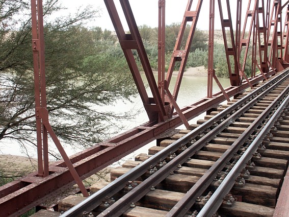
Railway Bridge over Holoog River: Railway Line: Grünau-Seeheim
Copyright of Photos: Dr. Klaus Dierks


TransNamib Train at Seeheim Station: Karas Region
Copyright of Photos: Dr. Klaus Dierks


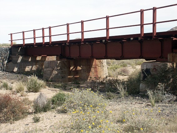
Fish River Railway Bridge at Seeheim: Seeheim-Aus Railway Line
Copyright of Photos: Dr. Klaus Dierks

Fish River at Seeheim: Karas Region
Copyright of Photo: Dr. Klaus Dierks

Grünau: Railway Line: Grünau-Seeheim: View to the West
Copyright of Photo: Dr. Klaus Dierks


Trunk Road 4/1: Seeheim to Goageb: Karas Region
Copyright of Photos: Dr. Klaus Dierks


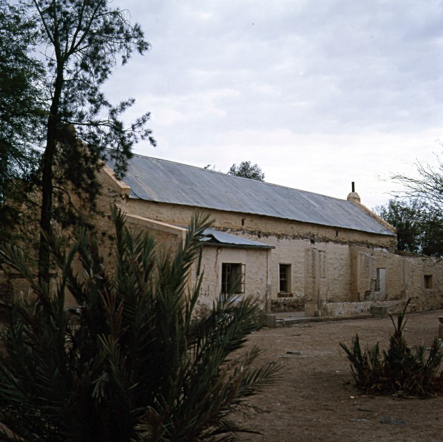
Bethany: Captain Joseph Frederik's II House: Karas Region
Copyright of Photos: Dr. Klaus Dierks


Bethany: London Missionary Schmelen's House: 1814: Karas Region
Copyright of Photos Dr. Klaus Dierks

Bethany: Spring: Karas Region
Copyright of Photo Dr. Klaus Dierks

Bethany: First Rhenish Missionary Church: 26.06.1859: Karas
Region
Copyright of Photo Dr. Klaus Dierks

Bethany: Rhenish Missionary Cemetery: Matthäus Gorth: died on
05.01.1853: #Goais (Grootfontein South)
Copyright of Photo Dr. Klaus Dierks

Bethany: Rhenish Missionary Cemetery: Hermann Heinrich Kreft:
died on 03.05.1875
Copyright of Photo Dr. Klaus Dierks

Bethany: Rhenish Missionary Cemetery: Johannes Heinrich Bam:
died on 26.09.1891
Copyright of Photo Dr. Klaus Dierks

Bethany: Second Rhenish Church: 1880s: Karas Region
Copyright of Photo Dr. Klaus Dierks


Asab River: north of Keetmanshoop: Rainy Season March 2002:
Karas Region
Copyright of Photos: Dr. Klaus Dierks

Keetmanshoop: Rhenish Church: Karas Region
Copyright of Photo Dr. Klaus Dierks


Quiver Tree Forest east of Keetmanshoop: Karas Region
Copyright of Photos: Dr. Klaus Dierks

Brukkaros Vulcan (Nama: Kaitsi !Gubeb) near Berseba: Karas
Region (Photo taken 1978)
Copyright of Photo: Dr. Klaus Dierks


Brukkaros Vulcan near Berseba: View from the South: Karas
Region: April 2003
Copyright of Photos: Dr. Klaus Dierks


Brukkaros Vulcan near Berseba: View from the South: Karas
Region: January 2004
Copyright of Photos: Dr. Klaus Dierks

Brukkaros-Vulcan near Berseba: View from the Crater Edge into
the Interior of the Vulcan: Karas Region: April 2003
Copyright of Photo: Dr. Klaus Dierks


Brukkaros-Vulcan near Berseba: View from the Crater Edge into
the Interior of the Vulcan: Karas Region: January 2004
Copyright of Photo: Dr. Klaus Dierks and Alexander Dierks (right photograph)


Brukkaros-Vulcan near Berseba: View from the Crater Edge to the
South (in Direction Berseba): Karas Region: January 2004
Copyright of Photo: Dr. Klaus Dierks

Main Road 98: Tses-Berseba: with Brukkaros Vulcan in the
Background: Fish River Bridge is under Construction: 1978
Copyright of Photo: Dr. Klaus Dierks

Main Road 98: Tses-Berseba: with Brukkaros Vulcan in the
Background: Fish River Bridge: September 2002
Copyright of Photo: Dr. Klaus Dierks


Main Road 98: Tses-Berseba: with Brukkaros Vulcan in the
Background: Fish River Bridge: January 2004
Copyright of Photo: Dr. Klaus Dierks


Berseba: founded by Rhenish Missionary Samuel Hahn: 17.10.1850:
the Church is built by Missionary Friedrich Wilhelm Weber: 1857
Copyright of Photos: Dr. Klaus Dierks


The Cemetery at Berseba: Karas Region
Copyright of Photos: Dr. Klaus Dierks

District Road 609 between Berseba and Keetmanshoop, near Gellap
Ost: Karas Region
Copyright of Photo: Dr. Klaus Dierks

The "Mukorob" (Finger of God), shortly before it
collapsed on December, 4th 1988: Just on the Brink of Namibian Independence: An old Nama
Fairy Tale told that the Rule of the "White Man" will come to an End if
this Rock falls
Copyright of Photo: Dr. Klaus Dierks

Trunk Road 1/2 between Keetmanshoop and Grünau near Narubis:
Karas Region
Copyright of Photo: Dr. Klaus Dierks
![]()
FROM SPES BONA AND THE TIRAS PLAINS TO LÜDERITZ VIA AUS
Copyright of Photo: Namibia Roads Authority


Aerial Views between Spes Bona and the Tiras Mountains: Karas
Region: January 2003
Copyright of Photos: Dr. Klaus Dierks


District Road 407 between Betta and Spes Bona: Karas Region
Copyright of Photos: Dr. Klaus Dierks


District Road 707 between Spes Bona and Tiras: along the Namib
Desert with the previous Restricted Diamond Area: Karas Region
Copyright of Photos: Dr. Klaus Dierks


Main Road 35: Helmeringhausen-Tiras: Karas Region: October 2004
Copyright of Photos: Dr. Klaus Dierks


Trunk Road 4/2: Goageb - Aus: built 1992/93: Karas Region
Copyright of Photos: Dr. Klaus Dierks

Aerial View of Aus: View to the South: Karas Region: January
2003
Copyright of Photos: Dr. Klaus Dierks

Aus between Keetmanshoop and Lüderitz: Karas Region: 1973
Copyright of Photo: Dr. Klaus Dierks


The British Prisoner of War Camp (1915-1919) at Aus
Copyright of Photos: Dr. Klaus Dierks


The Cemetery at Aus: Karas Region
Copyright of Photos: Dr. Klaus Dierks


The Savannah west of Aus: Just inside the "Diamond
Sperrgebiet": Karas Region
Copyright of Photos: Dr. Klaus Dierks


Aus to Lüderitz Railway Line: km 180 - km 183: West of Aus
(Beginning of new Construction at Aus Station: km 179,423 from Keetmanshoop): Completed
Layer Works to Sub Ballast Layer: Progress to Date: October 2004
Copyright of Photos: Dr. Klaus Dierks

Aus to Lüderitz Railway Line: km 181: West of Aus (Beginning of
new Construction at Aus Station: km 179,423 from Keetmanshoop): Completed Layer Works to
Sub Ballast Layer: Progress to Date: October 2004
Copyright of Photo: Dr. Klaus Dierks

Aus to Lüderitz Railway Line: km 182: West of Aus (Beginning of
new Construction at Aus Station: km 179,423 from Keetmanshoop): Section "Salz
Gossow": km 179+423 to km 220: Removal of old German "Krupp-Rails", nearly
100 Years old: View to the West: Direction Garub: Progress to Date: September 2002
Copyright of Photo: Dr. Klaus Dierks

Aus to Lüderitz Railway Line: km 184 + 000: Bridge No.1: West
of Aus: Old German Steel Bridge has been removed and will be removed by Reinforced
Concrete Culverts: Progress to Date: October 2004
Copyright of Photo: Dr. Klaus Dierks

Aus to Lüderitz Railway Line: km 186 + 000: Bridge No.3: West
of Aus: Old German Steel Bridge: Progress to Date: September 2002
Copyright of Photos: Dr. Klaus Dierks


West of Aus: Aus Vista: View to the South: The Desert is
flowering after late Winter Rains: September 2002
Copyright of Photos: Dr. Klaus Dierks

Aus to Lüderitz Railway Line: km 190: West of Aus: The old
German Steel Sleepers are stacked: View to the West: Progress to Date: September
2002
Copyright of Photo: Dr. Klaus Dierks

Aus to Lüderitz Railway Line: km 195: West of Aus: Station
Ausweiche, where the steep Ascent to Aus Nek commences: September 2002
Copyright of Photo: Dr. Klaus Dierks

Aus to Lüderitz Railway Line: km 200: Border between Farming
Area west of Aus and the "Diamond Sperrgebiet": September 2002
Copyright of Photo: Dr. Klaus Dierks

Aus to Lüderitz Railway Line: km 186,40: Beginning of new
Construction Section: November 2002: Salz-Gossow, Swakopmund: Six Kilometres Fill and
B-Layer are under Construction: View to the West: Direction Ausweiche and Garub: December
2002
Copyright of Photo: Dr. Klaus Dierks

Aus to Lüderitz Railway Line: km 186,40: Beginning of new
Construction Section: Salz-Gossow, Swakopmund: Six Kilometres Fill and B-Layer are under
Construction: View to the East: Direction Aus: December 2002
Copyright of Photo: Dr. Klaus Dierks


Aus to Lüderitz Railway Line: km 187: B-Layer is under
Construction: View to the West: Direction Ausweiche and Garub: December 2002
Copyright of Photos: Dr. Klaus Dierks


Aus to Lüderitz Railway Line: km 188: B-Layer is under
Construction: View to the West: Direction Ausweiche and Garub: December 2002
Copyright of Photos: Dr. Klaus Dierks

Aus to Lüderitz Railway Line: km 189+540: B-Layer is under
Construction: View to the East: Direction Ausvista: December 2002
Copyright of Photo: Dr. Klaus Dierks

Aus to Lüderitz Railway Line: km 189+540: B-Layer is under
Construction: View to the West: Direction Ausweiche and Garub: December 2002
Copyright of Photo: Dr. Klaus Dierks

Aus to Lüderitz Railway Line: km 186+700: A-Layer is completed:
View to the West: Direction Ausweiche and Garub: January 2003
Copyright of Photo: Dr. Klaus Dierks


Aus to Lüderitz Railway Line: km 187+100: A-Layer is under
Construction: View to the West: Direction Ausweiche and Garub: January 2003
Copyright of Photos: Dr. Klaus Dierks


Aus to Lüderitz Railway Line: Between km 186 and km 200:
Sub-Ballast is completed: View to the West: Direction Ausweiche and Garub: October
2004
Copyright of Photos: Dr. Klaus Dierks


Aus to Lüderitz Railway Line: km 189+000: Ostriches: View to
the Northwest: Direction Garub Mountain: January 2003
Copyright of Photo: Dr. Klaus Dierks


The Feral Horses at Garub originating from German Military
Horses: Beginning of 20th Century: 20 km west of Aus in the Namib Desert: Karas Region
Copyright of Photos: Dr. Klaus Dierks

Garub Station at the Aus to Lüderitz Railway Line (currently
under Re-construction) which was built between December 1905 and November 1906: 30 km west
of Aus: Karas Region
Copyright of Photo: Dr. Klaus Dierks

Garub Station at the Aus to Lüderitz Railway Line which was
built between December 1905 and November 1906: 30 km west of Aus: completed Sub-Ballast
Layer: View to the West in Direction Haalenberg: Karas Region: October 2004
Copyright of Photo: Dr. Klaus Dierks

Garub Station at the Aus to Lüderitz Railway Line which was
built between December 1905 and November 1906: 30 km west of Aus: completed Sub-Ballast
Layer: View to the South: Karas Region: October 2004
Copyright of Photo: Dr. Klaus Dierks

Garub Station at the Aus to Lüderitz Railway Line which was
built between December 1905 and November 1906: 30 km west of Aus: completed Sub-Ballast
Layer: View to the East in Direction Ausweiche: Karas Region: October 2004
Copyright of Photo: Dr. Klaus Dierks

The "Garub Water Railway Line" which provided the
Water for the Construction of the Aus to Lüderitz Railway Line: with German Writer
Jürgen Leskien: August 2002: Karas Region
Copyright of Photo: Dr. Klaus Dierks


The "Garub Water Railway Line": Karas Region
Copyright of Photos: Dr. Klaus Dierks


Flowers in the Namib Desert after good Winter Rains: near Garub:
August 2002: Karas Region
Copyright of Photos: Dr. Klaus Dierks

Fence of the Diamond Area No. 1: Namib Desert: Karas Region
Copyright of Photo: Dr. Klaus Dierks


Aerial View on Namib Desert: From the Khoichab Dunes to the
Garub Mountain (Dikker Willem): View to the Southwest: Karas Region: January 2003
Copyright of Photos: Dr. Klaus Dierks

Aerial View on Namib Desert: View to the Khoichab Dunes to the
Northwest: Karas Region: January 2003
Copyright of Photo: Dr. Klaus Dierks


Aerial View on Namib Desert: View from the Khoichab Dunes to the
Tiras Mountains in the Northwest: Karas Region: January 2003
Copyright of Photos: Dr. Klaus Dierks

Aerial View on Namib Desert: View to the Sinclair Area to the
West: Karas Region: January 2003
Copyright of Photo: Dr. Klaus Dierks


Aerial View on Namib Desert: View north of the Sinclair Area to
the West: Karas Region: January 2003
Copyright of Photos: Dr. Klaus Dierks


Aerial View on the Schwarzrand: West of Helmeringhausen: View to
the East: Karas Region: January 2003
Copyright of Photos: Dr. Klaus Dierks

Aerial View on the Schwarzrand: West of Helmeringhausen: With
Brukkaros in the Distance: 200 km to the East: Karas Region: January 2003
Copyright of Photo: Dr. Klaus Dierks

Khoichab Pan Restricted Area: Namib Desert: View to the South
East: Direction Garub 2 Borehole: Karas Region
Copyright of Photo: Dr. Klaus Dierks

Khoichab Pan Restricted Area: Namib Desert: View to the West:
Direction Garub-Mountain (Dikker Willem): Karas Region
Copyright of Photo: Dr. Klaus Dierks

Khoichab Pan Restricted Area: Namib Desert: Feral Horses: With
Garub-Mountain (Dikker Willem) in the South: Karas Region
Copyright of Photo: Dr. Klaus Dierks


Khoichab Pan Restricted Area: Namib Desert: Feral Horses: Karas
Region
Copyright of Photos: Dr. Klaus Dierks


Khoichab Pan Restricted Area: Namib Desert: Feral Horses: View
to the South: Karas Region
Copyright of Photos: Dr. Klaus Dierks

Khoichab Pan Restricted Area: Namib Desert: View to the
Southwest: Direction Garub-Mountain (Dikker Willem): Karas Region
Copyright of Photo: Dr. Klaus Dierks

Khoichab Pan Restricted Area: Namib Desert: Eureka Pass: View to
the North into the Khoichab Dunes and Tiras Mountains: Karas Region
Copyright of Photo: Dr. Klaus Dierks

Khoichab Pan Restricted Area: Namib Desert: Eureka: Euphorbia
"Bushman Candle": Karas Region
Copyright of Photo: Dr. Klaus Dierks

Khoichab Pan Restricted Area: Namib Desert: Eureka: Chameleon:
Karas Region
Copyright of Photo: Dr. Klaus Dierks

Khoichab Pan Restricted Area: Namib Desert: "Road to
Eternity": View to the Southeast: Leeukop Mountains: Karas Region
Copyright of Photo: Dr. Klaus Dierks


Khoichab Pan Restricted Area: Namib Desert: Images from the
Khoichab Dunes: November 2002: Karas Region
Copyright of Photos: Dr. Klaus Dierks

Khoichab Pan Restricted Area: Namib Desert: Euphorbia
Namibiensis "Elephant Foot": Karas Region
Copyright of Photo: Dr. Klaus Dierks


Khoichab Pan Restricted Area: Namib Desert: Images from the
Khoichab Forest at the Beginning of the Khoichab Pan: Many Century Old Camelthorn Trees
are dying due to the Extraction of Water of the Town of Lüderitz: November 2002: Karas
Region
Copyright of Photos: Dr. Klaus Dierks

Khoichab Pan Restricted Area: Namib Desert: !Nara Fruits: Staple
Food for San and Nama People in the Desert: Karas Region
Copyright of Photo: Dr. Klaus Dierks


Khoichab Pan Restricted Area: Namib Desert: Kirchberg: East of
Khoichab Pan: Ascent to the Caves with San Rockpaintings: November 2002: Karas Region
Copyright of Photos: Dr. Klaus Dierks

Khoichab Pan Restricted Area: Namib Desert: Kirchberg: East of
Khoichab Pan: View from Cave 1 to the North with Khoichab Dunes in the Background:
November 2002: Karas Region
Copyright of Photo: Dr. Klaus Dierks


Khoichab Pan Restricted Area: Namib Desert: Kirchberg: East of
Khoichab Pan: Cave 1 with recently discovered San Rockpaintings: Estimated C2 Period: 1200
BC to AD: November 2002: Karas Region
Copyright of Photos: Dr. Klaus Dierks

Khoichab Pan Restricted Area: Namib Desert: Kirchberg: East of
Khoichab Pan: Waterhole near Cave 1: November 2002: Karas Region
Copyright of Photo: Dr. Klaus Dierks


Khoichab Pan Restricted Area: Namib Desert: Kirchberg: East of
Khoichab Pan: Ascent from Cave 1 to Cave 2: November 2002: Karas Region
Copyright of Photos: Dr. Klaus Dierks


Khoichab Pan Restricted Area: Namib Desert: Kirchberg: East of
Khoichab Pan: Cave 2 with recently discovered San Rockpaintings: Estimated C2 Period: 1200
BC to AD: November 2002: Karas Region
Copyright of Photos: Dr. Klaus Dierks

Khoichab Pan Restricted Area: Namib Desert: Kirchberg: East of
Khoichab Pan: Cave 2 with recently discovered San Rock Engraving: Estimated C2 Period:
1200 BC to AD: November 2002: Karas Region
Copyright of Photos: Dr. Klaus Dierks

Khoichab Pan Restricted Area: Namib Desert: Kirchberg: East of
Khoichab Pan: Ascent to Cave 3 from the Base: Karas Region
Copyright of Photo: Dr. Klaus Dierks


Khoichab Pan Restricted Area: Namib Desert: Kirchberg: East of
Khoichab Pan: Ascent to Cave 3: Building Remains in the Form of Stone Circles at the
Kirchberg Settlement Site built by Pastoral Nomads in the Namib: Karas Region
Copyright of Photos: Dr. Klaus Dierks

Khoichab Pan Restricted Area: Namib Desert: Kirchberg: East of
Khoichab Pan: Ascent to Cave 3: Possible Good Look Cairn" (Nama: Heitsi-Eibib or
Haitse-aibeb) established by Pastoral Nomads in the Namib: Karas Region
Copyright of Photo: Dr. Klaus Dierks


Khoichab Pan Restricted Area: Namib Desert: Kirchberg: East of
Khoichab Pan: Cave 3 with recently discovered San Rockpaintings: Estimated C2 Period: 1200
BC to AD: November 2002: Karas Region
Copyright of Photos: Dr. Klaus Dierks


Namib Desert Images between Haalenberg and Kolmanskop: Karas
Region
Copyright of Photos: Dr. Klaus Dierks


Aus to Lüderitz Railway Line: Near Kolmanskop: km 300 (from
Keetmanshoop: 20 km from Lüderitz): The "End of Road" has not been reaches as
yet: From 2003 onwards the Line will be rebuilt
Copyright of Photos: Dr. Klaus Dierks


Aus to Lüderitz Railway Line: Station Grasplatz: km 296 (24 km
from Lüderitz)
Copyright of Photos: Dr. Klaus Dierks


Aus to Lüderitz Railway Line: km 290 (approx. 30 km from
Lüderitz)
Copyright of Photos: Dr. Klaus Dierks

Aus to Lüderitz Railway Line: approx. km 290 (approx. 30 km
from Lüderitz): The 12 km Section from approx. km 290 to approx. km 300 is crossing a
heavy Sand Dune Section: New innovative Engineering Solutions have to be found for the
Rebuilding of this Railway Section (Phase 2: Haalenberg-Lüderitz): One Solution is the
Stabilisation of the Sand Dunes (See Photo: Test Stabilisation): Others are Tunnelling,
the Lifting of the Gradeline with appropriate Crossections or alternative Alignments
Copyright of Photo: Dr. Klaus Dierks


Aus to Lüderitz Railway Line: km 252: Starting Point of Phase 1
of the Re-Construction of the Railway Line: Section of Roads Contractor Company (RCC): km
252+000 to km 220+000: Aus-Haalenberg: View to the West: Direction Haalenberg
Copyright of Photos: Dr. Klaus Dierks


Aus to Lüderitz Railway Line: km 252: Construction of Railbed:
New Rails on right Side: View to the East: Direction Station Tsaukaib (Tsau||kaib: Nama:
Heavy Soft Sand)
Copyright of Photos: Dr. Klaus Dierks


Aus to Lüderitz Railway Line: km 252: Construction of B Layer
(A Layer and Sub-Ballast to follow): View to the West: Direction Haalenberg: Progress to
Date: August 2002
Copyright of Photos: Dr. Klaus Dierks

Aus to Lüderitz Railway Line: km 246+000: Construction of A
Layer (Sub-Ballast to follow): Station Tsaukhaib: View to the East: Direction Garub:
Progress to Date: November 2002 (10 km between km 242 to 252 to A-Level are
completed/under Construction)
Copyright of Photo: Dr. Klaus Dierks


Aus to Lüderitz Railway Line: km 246+000: Construction of A
Layer (Sub-Ballast to follow): Station Tsaukhaib: View to the West: Direction Haalenberg:
Progress to Date: November 2002 (10 km between km 242 to 252 to A-Level are
completed/under Construction)
Copyright of Photos: Dr. Klaus Dierks


Aus to Lüderitz Railway Line: km 240+000: Construction of Fill:
View to the East: Direction Garub: Progress to Date: January 2003 (Roadbed and Fill 14,20
km between km 237+800 to 252; B-Layer 10,20 km between Km 252 to 241+800; A-Layer 9,20 km
between Km 252 to 242+800 and Subballast 3,20 km between km 252 and 248+800)
Copyright of Photos: Dr. Klaus Dierks

Aus to Lüderitz Railway Line: km 246+000: A Layer completed:
View to the East: Direction Garub: Progress to Date: January 2003: 9,20 km
Copyright of Photo: Dr. Klaus Dierks


Aus to Lüderitz Railway Line: km 246+000: Construction of
Pre-Fabricated Box-Culvert: Progress of Culverts to Date: January 2003: 5 km
Copyright of Photos: Dr. Klaus Dierks

The southern Port City of Lüderitz, 1971: View from South to
North: Karas Region
Copyright of Photo: Dr. Klaus Dierks

The southern Port City of Lüderitz, 2004: View from the
Southeast: Karas Region
Copyright of Photo: Dr. Klaus Dierks


In Lüderitz still lives Namibia's German Colonial Past: 1971
Copyright of Photos: Dr. Klaus Dierks


Lüderitz at an early Spring Morning: August 2002
Copyright of Photos: Dr. Klaus Dierks

The "Felsenkirche" (Rock Church) at Lüderitz with a
View to the North
Copyright of Photo: Dr. Klaus Dierks

View from the "Felsenkirche" to the North (with Goerke
House at the Forefront)
Copyright of Photo: Dr. Klaus Dierks


Stained-Glass Windows in the "Felsenkirche" at
Lüderitz
Copyright of Photos: Dr. Klaus Dierks

The 1909 built "Goerke House" at Lüderitz
Copyright of Photo: Dr. Klaus Dierks

The new Waterfront at Lüderitz which was opened in 2002
Copyright of Photo: Dr. Klaus Dierks

Shark Island at Lüderitz with a View to the South-East: Shark
Island is known for its infamous Concentration Camp during the German Colonial Era:
1905-1907
Copyright of Photo: Dr. Klaus Dierks

Shark Island at Lüderitz with a View to the North
Copyright of Photo: Dr. Klaus Dierks

Memorial Plaque of Franz Adolf Eduard Lüderitz at Shark Island:
Only the Memories of the German Colonial Past are evident: There is no Memorial for the
more than One Thousand Namibians - Men, Women and Children - who perished at the Hands of
the German Authority at the Shark Island Concentration Camp: 1905-1907
Copyright of Photo: Dr. Klaus Dierks
![]()
RESTRICTED DIAMOND AREA (SPERRGEBIET)
Copyright of Photo: Namibia Roads Authority

"Kleiner Bogenfels" between Grosse Bucht and Diaz
Point southwest of Lüderitz: 2004: Karas Region
Copyright of Photo: Dr. Klaus Dierks


Grosse Bucht southwest of Lüderitz: 2004: Karas Region
Copyright of Photo: Dr. Klaus Dierks

The Diamond Ghost Town of Kolmanskop east of Lüderitz: 1971:
Karas Region
Copyright of Photo: Dr. Klaus Dierks

Image from the deserted Town of Kolmanskop
Copyright of Photo: Dr. Klaus Dierks


Kolmanskop: August 2002: Karas Region
Copyright of Photos: Dr. Klaus Dierks


The Sperrgebiet Coast Line between Lüderitz and Oranjemund is
one of the desolatest Coast Areas in the World: August 1990
Copyright of Photos: Dr. Klaus Dierks


The Remains of the Old Diamond Processing Plant at Elizabeth
Bay: January 2000
Copyright of Photos: Dr. Klaus Dierks


The Diamond Mine at Prinzenbucht in the Sperrgebiet: January
2000
Copyright of Photos: Dr. Klaus Dierks

The Diamond Mine at Pomona from the Air: August 1990
Copyright of Photo: Dr. Klaus Dierks


The Diamond Mine at Pomona: January 2000
Copyright of Photo: Dr. Klaus Dierks

The Bogenfels southwest of the Diamond Mine at Pomona from the
Air: August 1990
Copyright of Photo: Dr. Klaus Dierks


The Bogenfels: January 2000
Copyright of Photos: Dr. Klaus Dierks


The Atlantic Off-Shore Island Plumpudding in the Sperrgebiet
from the Air: August 1990
Copyright of Photo: Dr. Klaus Dierks
![]()
FROM ||KHAUXA!NAS TO WARMBAD AND THE KALAHARI
Copyright of Photo: Namibia Roads Authority

The Great Karas Mountains from the West: Kuchanas: January 2004
Copyright of Photo: Dr. Klaus Dierks

Access Road to ||Khauxa!nas: Main Road 26: Through the Great
Karas Mountains: January 2004
Copyright of Photo: Dr. Klaus Dierks

The Great Karas Mountains from the East: February 1987
Copyright of Photo: Dr. Klaus Dierks

The Great Karas Mountains from Aob (Gaitsanes): April 2003
Copyright of Photo: Dr. Klaus Dierks

German War Memorial: Reflecting the Battle of Aob between Jakob
Marengo and Captain Kirchner: 10.03.1905
Copyright of Photo: Dr. Klaus Dierks

Landscape east of ||Khauxa!nas: With View to the Great Karas Mountains in the
West: Karas Region: April 2003
Copyright of Photo: Dr. Klaus Dierks

Landscape east of ||Khauxa!nas: With View to the Gurus River in
the South: District Road 612: Karas Region: April 2003
Copyright of Photo: Dr. Klaus Dierks

||Khauxa!nas is the oldest so far known Pre-Colonial Settlement
in an Engineering Sense: East of the Great Karas Mountains: View from the Top of the Ruins
to the East: February 1987
Copyright of Photo: Dr. Klaus Dierks

||Khauxa!nas: View from the Top of the Ruins to the East:
October 1988
Copyright of Photo: Dr. Klaus Dierks


||Khauxa!nas: View from the Top of the Ruins to
the East: With Protection Wall in the Background: April 2003
Copyright of Photos: Dr. Klaus Dierks


||Khauxa!nas: View from the Top of the Ruins to
the East: With Protection Wall in the Background: January 2004
Copyright of Photos: Dr. Klaus Dierks


||Khauxa!nas: Karen (née von Bremen) and Klaus
Dierks (left Photograph with Jakob Marengo's House): January 2004
Copyright of Photos: Dr. Klaus Dierks and Alexander Dierks (left two
phographs)

||Khauxa!nas: View from the Top of the Ruins to
the West: With the Great Karas Mountains in the Background: April 2003
Copyright of Photo: Dr. Klaus Dierks


||Khauxa!nas: Top of the Ruins: Details of
Structural Elements: April 2003 and January 2004 (Top
Row)
Copyright of Photos: Dr. Klaus Dierks

||Khauxa!nas: View from the Top of the
Mountain: Onto the Back River: April 2003
Copyright of Photo: Dr. Klaus Dierks

||Khauxa!nas: View from the Top of the
Mountain: Onto the Back River: January 2004
Copyright of Photo: Dr. Klaus Dierks


Possible House of Klaas Afrikaner on the ||Khauxa!nas Mountain:
April 2003
Copyright of Photos: Dr. Klaus Dierks

Possible House of Klaas Afrikaner on the ||Khauxa!nas Mountain:
January 2004
Copyright of Photo: Dr. Klaus Dierks


Protective Wall around the ||Khauxa!nas Mountain Plateau: April
2003
Copyright of Photos: Dr. Klaus Dierks


Protective Wall around the ||Khauxa!nas Mountain Plateau:
January 2004
Copyright of Photos: Dr. Klaus Dierks


The Rectangular Building in ||Khauxa!nas: "Marengo's
House": April 2003
Copyright of Photos: Dr. Klaus Dierks


The Rectangular Building in ||Khauxa!nas: "Marengo's
House": January 2004
Copyright of Photos: Dr. Klaus Dierks

Tombstones (Heitsi Eibeb) on the Eastern Side of the ||Khauxa!nas
Mountain Fortress: 1987
Copyright of Photo: Dr. Klaus Dierks

Tombstones (Heitsi Eibeb) on the Eastern Side of the ||Khauxa!nas
Mountain Fortress: April 2003
Copyright of Photo: Dr. Klaus Dierks

Bak River at ||Khauxa!nas east of the Great Karas Mountains:
February 1987
Copyright of Photo: Dr. Klaus Dierks

Precolonial Pathway to the Top of the ||Khauxa!nas Ruins: April
2003
Copyright of Photo: Dr. Klaus Dierks

Bak River at ||Khauxa!nas east of the Great Karas Mountains:
View from the Pathway to the Top of the ||Khauxa!nas Ruins: April 2003
Copyright of Photo: Dr. Klaus Dierks


Bak River at ||Khauxa!nas: View from the Pathway to the Top of
the ||Khauxa!nas Ruins: During the Rainy Season 2003/2004: January 2004
Copyright of Photo: Dr. Klaus Dierks

Grave of the German Unit "Nikolai von Stempel": at
Gugunas South (||Khauxa!nas): 30.08.1904: The Skirmish with Jakob Marengo initiated the
Nama War in the South
Copyright of Photo: Dr. Klaus Dierks


Warmfontein: Gurus River: Karas Region: April 2003
Copyright of Photos: Dr. Klaus Dierks

Rockpainting near ||Khauxa!nas: Warmfontein: Gurus River:
March1996
Copyright of Photo: Dr. Klaus Dierks


Rockpainting near ||Khauxa!nas: Warmfontein: Gurus River: April
2003
Copyright of Photos: Dr. Klaus Dierks

Robber Henrick's Place (Narudas) or Klip Fontein south-west of
||Khauxa!nas, possibly Marengo's camp during February/March 1905 (Photo taken 1988)
Copyright of Photo: Dr. Klaus Dierks

The Narudas Ruins: View to the Southwest into the Great Karas
Mountains: March 2001
Copyright of Photo: Dr. Klaus Dierks


The Narudas Ruins: View to the North, to the Narudas Peak: April
2003
Copyright of Photos: Dr. Klaus Dierks


Access Climb to the Narudas Ruins from the North: April 2003
Copyright of Photos: Dr. Klaus Dierks


View from the Narudas Ruins to the Northwest into the Narudas Gorge: April 2003
Copyright of Photos: Dr. Klaus Dierks


View from the Narudas Ruins to the South to the highest Point of
the Ruins: April 2003
Copyright of Photos: Dr. Klaus Dierks

View from the Narudas Ruins to the East in direction of
||Khauxa!nas: April 2003
Copyright of Photo: Dr. Klaus Dierks

The highest Point of the Narudas Ruins: April 2003
Copyright of Photo: Dr. Klaus Dierks


The War Cemetery at Narudas: Depicting various Battles and
Skirmishes between the Germans and Jakob Marengo during 1905
Copyright of Photos: Dr. Klaus Dierks


On a Search Trail for new Pre-colonial Ruins in the Great Karas
Mountains: From Narudas via Witkrans, Garies to Sandmund: Karas Region: April 2003
Copyright of Photos: Dr. Klaus Dierks

Pre-colonial Ruins in the Great Karas Mountains: Farm Garies:
Possible Watch Tower over a Waterhole in a Riverbed: In the Background: Garies Hill with
numerous Ruins: Karas Region: April 2003
Copyright of Photo: Dr. Klaus Dierks

Pre-colonial Ruins in the Great Karas Mountains: Garies Possible
Watch Tower over a Waterhole in a Riverbed: Karas Region: April 2003
Copyright of Photo: Dr. Klaus Dierks

Pre-colonial Ruins in the Great Karas Mountains: Sandmund: In
the Background: Narudas Poort: Karas Region: April 2003
Copyright of Photo: Dr. Klaus Dierks

Pre-colonial Ruins in the Great Karas Mountains: Sandmund: View
to the South: Narudas Poort: Karas Region: April 2003
Copyright of Photo: Dr. Klaus Dierks


Recently discovered Precolonial Nama Ruins: Top of the Great
Karas Mountains: Garies Hill: View to the South: Garies: Possible Secret Fortress built by
Jakob Marengo: April 2003
Copyright of Photos: Dr. Klaus Dierks

Precolonial Nama Ruins: Top of the Great Karas Mountains: Garies
Hill: View to the Southeast: To the Narudas Poort: Garies: April 2003
Copyright of Photo: Dr. Klaus Dierks

Precolonial Nama Ruins: Top of the Great Karas Mountains: Garies
Hill: View to the West: With Lord Hill (Schroffenstein: Highest Peak in the Great Karas
Mountains) in the Background: Garies: April 2003
Copyright of Photos: Dr. Klaus Dierks


The Hot Springs of Warmbad, 2001
Copyright of Photo: Dr. Klaus Dierks


The old "Pastorie" of Warmbad which is built on the
Foundations of the House which was established by the London Missionary Society Brothers
Abraham and Christian Albrecht in 1805, October 1988
Copyright of Photos: Dr. Klaus Dierks

The old "Pastorie" of Warmbad which is built on the
Foundations of the House which was established by the London Missionary Society Brothers
Abraham and Christian Albrecht in 1805, April 2003
Copyright of Photo: Dr. Klaus Dierks


The Delapidated Church of the Rhenish Missionary
Society at Warmbad, inaugurated by Missionary Weber in 1877, Photo taken in October 1988
Copyright of Photos: Dr. Klaus Dierks


The Re-Built (1990) Church of the Rhenish Missionary Society at Warmbad, inaugurated by Missionary Weber in 1877
, April 2003
The Grave of the Bondelswart (!Gami-#nun) Chief, Jan Abraham
Christian (Tōasib: |Nanseb Kaib #Naoxamab), in Warmbad (Old Location) who fell against
the Germans (Walter Jobst) on 25.10.1903 and initiated the German-Namibian War, 1903-1909
Copyright of Photo: Dr. Klaus Dierks

Remains of the German Fort at Warmbad
Copyright of Photo: Dr. Klaus Dierks


The Cemetery in Warmbad with many German War Graves of the
various Battles around Warmbad between 1903 and 1907
Copyright of Photos: Dr. Klaus Dierks


The Cemetery in Warmbad: With some Graves of the Bondelswart
Chiefs of Warmbad
Copyright of Photos: Dr. Klaus Dierks

The Cemetery in Warmbad: With a Grave reflecting the History of
the Kharaskhoma Syndicate of the South
Copyright of Photo: Dr. Klaus Dierks


!Gami-#nun Women at Warmbad, October 1988
Copyright of Photos: Dr. Klaus Dierks

Gabis, West of Warmbad
Copyright of Photo: Dr. Klaus Dierks

83 Years old Anna Veldskoen, a Nama Lady, living in Gabis in the
Bondelswart Area, 2001
Copyright of Photo: Dr. Klaus Dierks

Timotheus Morris (born 06.05.1952), Grandson of Abraham Morris
who fell against the South Africans during the Bondelswart Uprising in 1922
Copyright of Photo: Dr. Klaus Dierks

Kalahari Landscape northeast of Koės: District Road 511: Karas
Region: April 2003
Copyright of Photo: Dr. Klaus Dierks


Kalahari Landscape northeast of Koės: District Road 616 into the Interior of the
Kalahari: "Sandspoor Road" in deep Sand: Karas Region: April 2003
Copyright of Photos: Dr. Klaus Dierks

German War Cemetery at Koės: Reflecting the Crushing of various
Nama Uprisings during 1895 in the Kalahari Desert
Copyright of Photo: Dr. Klaus Dierks


German War Cemetery at Koės: Reflecting the many Battles and
Skirmishes between Germans and Nama in the Kalahari Desert: Between 1904 and 1912
Copyright of Photos: Dr. Klaus Dierks


German War Cemetery at Koės: Reflecting the Battle between the
German Unit "Lengerke" and the ||Hawoben (Veldschoendragers) under the Command
of Chief Jan Hendrik: 15.12.1904
Copyright of Photos: Dr. Klaus Dierks

German War Cemetery at Koės: Reflecting various Skirmishes
around Koės between January and October 1905
Copyright of Photo: Dr. Klaus Dierks

German War Cemetery at Koės: Reflecting the Skirmish between
surviving Witbooi Nama and Germans at Kirris Ost: 02.11.1905
Copyright of Photo: Dr. Klaus Dierks

German War Cemetery at Koės: One of the many Casualties in the
Kalahari Sand Dunes during the German Nama War in the Kalahari from 1904 to 1912: Hardap
Region: April 2003
Copyright of Photos: Dr. Klaus Dierks

German War Cemetery at Koės: Reflecting the Skirmish of Kubub
between Germans and the Fransman Nama (!Khara-khoen) under Simon Koper:
08.03.1908
Copyright of Photo: Dr. Klaus Dierks

Kalahari Landscape south of Koės: District Road 611: Karas
Region: April 2003
Copyright of Photo: Dr. Klaus Dierks

Kalahari Landscape south of Koės: View to the Great Karas
Mountains from the Northeast: : Karas Region: April 2003
Copyright of Photo: Dr. Klaus Dierks

Kalahari Landscape southwest of Aroab: District Road 612:
Warmfontein: Karas Region: April 2003
Copyright of Photo: Dr. Klaus Dierks

Warmfontein: Grave of a German Soldier who was killed 1915
during World War One in Vellicke
Copyright of Photo: Dr. Klaus Dierks

Warmfontein: Grave of the Mother of Johannes Louw, Advisor to
Jakob Marengo: Karas Region: April 2003
Copyright of Photo: Dr. Klaus Dierks

Warmfontein: Grave of Johannes Louw, Advisor to Jakob Marengo:
Interesting is that the Grave has been "vandalised": Karas Region: April 2003
Copyright of Photo: Dr. Klaus Dierks

Warmfontein: Next to the Grave of Johannes Louw, Advisor to
Jakob Marengo are some unnamed Nama Graves, probably one could belong to Johannes Louw's
Nama Wife
Copyright of Photo: Dr. Klaus Dierks